
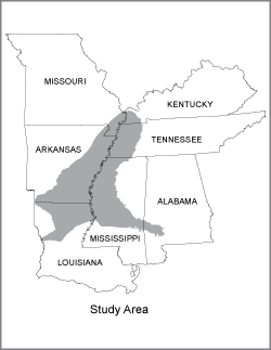
Mississippi Alluvial Plain (MAP) Regional Water Availability Study
Reports & Data Releases
Web Applications
- Interactive Mississippi Embayment Regional Aquifer (MERAS) Hydrogeologic Framework.
- Interactive Mississippi Embayment Regional Aquifer (MERAS) Water Use.
- Shellmound, Mississippi Geophysical Survey.
Data
- Groundwater data for the Mississippi Alluvial Plain.
- USGS: National Water Information System - Mapper.
New Publications
Abstracts and Presentations
-
Abstract — December 2016
Development of Monthly Water Budget Estimates for the CONUS and Application to the Mississippi Alluvial Plain by Meredith Reitz, Ward E. Sanford, Gabriel B. Senay, Wade H. Kress, and David Ladd -
Abstract — December 2016
Using FOSM-Based Data Worth Analyses to Design Geophysical Surveys to Reduce Uncertainty in a Regional Groundwater Model Update by Bruce D. Smith, Dr. Jeremy White, Wade H. Kress, Brian R. Clark, and Dr. Jeannie R.B. Barlow -
Abstract — December 2016
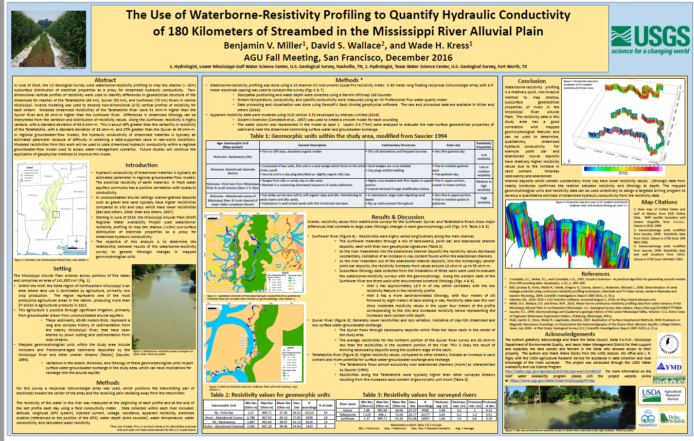
Water-borne continuous resistivity profiling data from select streams of the Mississippi Alluvial Plain in northwestern Mississippi by Benjamin V. Miller, David S. Wallace, and Wade H. Kress -
 Abstract — April 2017
Coupling Modeling with Monitoring to Assess Water Availability in the Mississippi Alluvial Plain by Wade H. Kress, Brian R. Clark, and Dr. Jeannie R.B. Barlow -
Abstract — April 2017
Characterizing groundwater and surface-water interaction throughout the Mississippi Delta using hydrograph-separation techniques combined with near-stream geophysical and groundwater-level data by Courtney Killian, Dr. Jeannie R.B. Barlow, Dr. Paul Barlow, Wade H. Kress, and Dr. Darrel Schmitz -
Abstract — April 2017
Surface-Geophysical Surveys to Characterize Lithological Controls on Aquifer Recharge and Surface Water–Groundwater Exchange by Benjamin V. Miller, Wade H. Kress, and David Ladd -
Abstract — April 2017
Water Availability in the Mississippi Delta: Initial Assessment of Alternative Water-Supply Scenarios by Dr. Jeannie R.B. Barlow, and Connor J. Haugh -
Abstract — April 2017
Estimating water budget components of evapotranspiration, recharge, and runoff for Mississippi and the Mississippi Alluvial Plain by Dr. Meredith Reitz, Ward E. Sanford, Gabriel B. Senay, and Wade H. Kress -
 Abstract — April 2017
Coupling Monitoring and Modeling to improve understanding of water availability in the Mississippi River Alluvial Plain. by Drew A. Westerman, Wade H. Kress, Meredith Reitz, and Brian R. Clark -
 Abstract — December 2017
Session: Mississippi Alluvial Plain Groundwater. by Wade H. Kress, Drew A. Westerman, Meredith Reitz, David Ladd, Courtney Killian, Ryan Adams, Connor Haugh, Brian R. Clark, and others -
 Poster — December 2016
The Use of Waterborne-Resistivity Profiling to Quantify Hydraulic Conductivity of 180 Kilometers of Streambed in the Mississippi River Alluvial Plain by Benjamin V. Miller, David S. Wallace, and Wade H. Kress -
 Presentation — October 2016
Mississippi Alluvial Plain Water Availability Project Presented by Wade H. Kress -
 Presentation — December 2016
Characterizing Delta Aquifers and Streams Presented by Wade H. Kress -
 Poster — January 2018
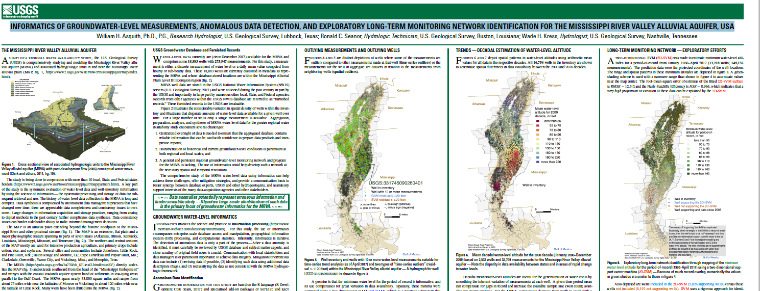
Informatics of Groundwater-Level Measurements, Anomalous Data Detection, and Exploratory Long-Term Monitoring Network Identification for the Mississippi River Valley Alluvial Aquifer, USA by William H. Asquith, Ph.D, P.G., Ronald C. Seanor, and Wade H. Kress
Data Releases
-
 Waterborne resistivity surveys for streams in the Mississippi Alluvial Plain, 2017 by Benjamin V. Miller, Ryan F. Adams, Jordan L. Wilson, and Wade H. Kress
 -
Water-borne continuous resistivity profiling data from select streams of the Mississippi Alluvial Plain in northwestern Mississippi by Benjamin V. Miller, David S. Wallace, and Wade H. Kress
Expected Future Data Releases
- Geophysical logs and hydrogeologic unit altitudes for boreholes within the Mississippi Alluvial Plain.
- Hydrogeologic framework representing the altitude and thickness of units within the Mississippi Alluvial Plain.
- Discretized grids representing recharge from 1900 to 2015 within the Mississippi Alluvial Plain.
- Digitized Geomorphology polygons within the Mississippi Alluvial Plain.
- Modeled Surface-water streamflow estimates for streams within the Mississippi Alluvial Plain from 1900 to 2015.
- Compilation of water-use data from 1900-2015 for surface and groundwater within the Mississippi Alluvial Plain.
- Compilation of water-quality data for groundwater within the Mississippi Alluvial Plain.
- Potentiometric map of the groundwater levels for the Mississippi Alluvial Plain.
Expected Future Reports
- Scientific Investigations Report on the hydrogeologic framework.
- Scientific Investigations Report describing water-use model aimed to estimate irrigation water use.
- Scientific Investigations Report documenting the update to the Mississippi Embayment Regional Aquifer Study (MERAS) numerical groundwater model including model input datasets and uncertainty analysis.
- Professional Paper describing trends and projections in groundwater availability for the Mississippi Alluvial Plain.
- Fact Sheet describing key findings.
More Information
- Mississippi Embayment Regional Aquifer Study (MERAS)
- Yazoo Mississippi Delta Joint Water Management District
- Mississippi Department of Environmental Quality: Land and Water Resources
Past Publications
-
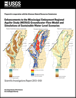 Scientific Investigations Report 2013-5161
Enhancements to the Mississippi Embayment Regional Aquifer Study (MERAS) and simulations of sustainable water-level scenarios by B.R. Clark, D.A. Westerman, and D.T. Fugitt -
 Scientific Investigations Report 2012-5072
Effects of Groundwater withdrawals associated with combined-cycle combustion turbine plants in west Tennessee and northern Mississippi by C.J. Haugh -
 Scientific Investigations Report 2011-5215
Simulation of the effects of groundwater withdrawals on water-level altitudes in the Sparta aquifer in the Bayou Meto-Grand Prairie area of eastern Arkansas, 2007-37 by B.R. Clark, D.A. Westerman and D.T. Fugitt -
 Fact Sheet 2011-3115
A New Tool to Assess Groundwater Resources in the Mississippi Embayment by B.R. Clark and D.A. Freiwald -
 Professional Paper 1785
Groundwater Availability of the Mississippi Embayment by B.R. Clark, R.M. Hart, and J.J. Gurdak -
 Scientific Investigations Report 2011-5019
Simulation of Water-Use Conservation Scenarios for the Mississippi Delta Using an Existing Regional Groundwater Flow Model by J.R.B. Barlow and B.R. Clark -
 Scientific Investigations Report 2009-5172
The Mississippi Embayment Regional Aquifer Study (MERAS): Documentation of a Groundwater-Flow Model Constructed to Assess Water Availability in the Mississippi Embayment by B.R. Clark and R.M. Hart -
 Scientific Investigations Report 2008-5192
Geophysical Log Database for the Mississippi Embayment Regional Aquifer Study (MERAS) by R.M. Hart and B.R. Clark -
 Scientific Investigations Report 2008-5098
Digital Surfaces and Thicknesses of Selected Hydrogeologic Units within the Mississippi Embayment Regional Aquifer Study (MERAS) by R.M. Hart, B.R. Clark, and S.E. Bolyard -
 Scientific Investigations Map 3014
Potentiometric Surface in the Sparta-Memphis Aquifer of the Mississippi Embayment Regional, Spring 2007 by T.P. Schrader