Ozark Plateaus Groundwater Availability Study Overview
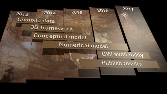
The U.S. Geological Survey's Groundwater Resources Program (GWRP) is conducting an assessment of groundwater availability throughout the United States to gain a better understanding of the status of the Nation's groundwater resources and how changes in water use and climate may affect those resources. Assessments will be completed for the Nation's principal aquifer systems to help characterize how much groundwater is currently available, how groundwater availability is changing, and how much groundwater we can expect to have in the future ( Source: USGS ). Groundwater is an important resource in the Ozark Plateaus area, therefore the GWRP is supporting a groundwater availability assessment of the Ozark Plateaus aquifer system beginning in 2014.
The primary objectives of this assessment are to quantify current groundwater resources, evaluate how these resources have changed over time, and provide the tools needed to simulate system response to future human-related and environmental stresses. Additionally, this proposed regional assessment will provide temporal information about the inflows, outflows, and changes in system-wide groundwater storage and provide information to assist in the evaluation and design of existing and new groundwater monitoring networks. This proposed assessment complements previous simulation models and builds upon the Ozark Regional Aquifer System Analysis work from the 1980's and 90's.